First stop today was El Morro National Monument in NM.. There are two paths available to see here, Inscription Rock Trail and The Headland Trail. I only had an hour or so today so went on the Inscription Rock Trail in order to check out the Petroglyphs. Hope to return Friday and do the second trail, it is said to take at least two hours...
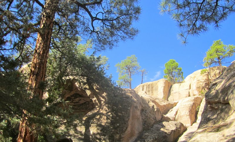
Lets start with the surrounding area before getting to the bluff.. If my bad spanish is close I think El Morro means "headland" or "The Bluff" ??? Not really sure...
 |
| First look at the trail when leaving the visitor center. |
 |
| Land around the bluffs |
 |
I really like this shot..
|
When walking up to the trail one of the first thinks I noticed was the fresh smell of the Juniper trees that surround the area. Unfortunately in recent times due to over grazing and fire suppression for the last century. The park systems are trying a variety of methods in an effort to restore the environment to what it once was, high elevation grassland, dotted with rabbitbrush and saltbush.
So why did so many people stop at El Morro? The answer is very simple, a fresh water pool, it is fed by rainfall in the summer and by melting snows. There is no spring so the water level goes up and down as weather changes. The pool is never empty and can hold 200,000 gallons of water when full.
 |
| If you can read this it explains things better then I could. |
 |
| The pool |
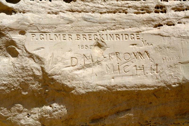
The Petroglyphs cover American Indian, Spanish, and Anglo travels. Both men and women stayed at El Morro when passing through the area. The following are only a few of the inscriptions that have been left as reminders of past visits to the pool.
 |
| When I noticed this sign I thought it was interesting. What would have happened if this sign had always been up? Now the future will not know that I was there on July 20th, 2011. Just to top it off I could not even get any water from the pool.. :-( |
 |
| Will not try to explain each photo, some are in English others in Spanish.. Nothing from current times.. |
Next stop along the road today was the Ice Cave and Bandera Volcano... First thing you see when you pull up is the Old Time Trading Post. The post was built in 1930's with a saloon and dance hall. At the time the logging industry and Zuni RR was in full swing. The saloon sold cold beer kept cold using ice from the caves. It was not until 1946 that the ice caves were turned into a tourist attraction.


The trees that grow on the lava face a special type of problem. This lava flow is
rich in iron content, this draws lightning strikes to the trees growing in it.
The tree pictured below was struck in July, 1992. Lightning strikes are a common
cause of forest fires.
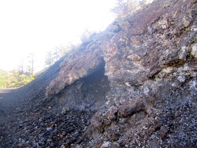
This type of lava formation is called a spatter cone. Spattercones are formed when minor vents form in the molten lava. A surge of hot air rushes through the lava forming surface tubes and minor vents. When the air breaks through the surface, lava will splash out forming a type of blow hole that you see here.
According to the information given out at the trading post, this is a good spot to see a variety of wildlife that inhabits this area. Most likely to be seen are chipmunks, squirrels, lizards and birds during the day. In the mornings and evenings you might spot deer and elk. Occasionally a bear or a mountain lion will wander through. During the summer it is not uncommon to see a bull snake on this trail. The only thing I saw was a few lizards..
There are a number of other volcanoes that make up the El Malpais region. There are 29 volcanoes in this area. Some of the ones that can be seen from the trail are15 of them. Starting from your right, southwestern side, there is Bandera's twin, Cerro Bandera (the largest, closest one). Moving to the East, the closest ones are: Arizona, Comadre, Americana, Rendaja, Leonides, Hoya De Cibola, Hueto, Lost Woman, Twin Craters, Lava Crater, El Calderon and Candelaria Crater. Good luck finding them from the photos... I am not sure I can..
This volcano is a cinder cone. The volcano began as the earth started to swell. Eventually a
crack broke open and high pressure lava began spraying out. The molten rock hardened in mid air and fell back down to the ground as cinders. Photos below shows the various sized cinders that make up this mountain.
Bandera Crater is the largest volcano in the region. It erupted around 10,000 years ago. There were two stages of the eruption: first the cinder cone developed, then a massive lava flow broke out. The molten lava reaches temperatures above 2,000 degrees
Fahrenheit. Bandera's lava flow is nearly 23 miles long. At the end of the eruption, the lava suddenly fell back down the main vent making the bottom of the cone deeper than the outside lava flow. This crater is nearly 1,400 feet wide at the top and roughly 800 deep. Over time, erosion and gravity take their toll on the crater and it is slowly filling up as cinders and rocks fall down into it. This makes for a very fragile environment.
The trees growing in lava find it hard to establish deep roots. The results are that the trees grow to be twisted and gnarled. Also, the shallow roots fail to support the trees in strong winds. You can see several fallen trees along the trails. Yet the lava protected many
trees from the loggers in the early days. The tree off the trail with the yellow ribbon is believed to be among the oldest living Douglas Fir trees in New Mexico. It isapproximately 700 years old.
The Ice Cave
The temperature in this cave never gets above 31 degrees Fahrenheit. As rain
water and snow melt seep into this cave, the ice floor thickens. The floor of the ice
is approximately 20 feet thick. The deepest ice is the oldest and dates back 3,400
years. The green tint is caused by an Arctic algae. The back wall was formed in the early days when ancient Indians and early settlers mined the ice. In 1946, ice removal was stopped at which time the ice wall was nearly 12 feet high. Since then, the ice floor has risen
relative to the back wall. The rate of ice accumulation varies with annual precipitation. The cause of original formation of ice 3,400 years ago is uncertain. However, its perpetuation is due to a combination of existing conditions that make a natural ice box: 20 feet of ice in a well insulated cave shaped to trap frigid air. The Ice Cave was known to the Pueblo Indians as
the Winter Lake.
Anyone still reading this??? If so I still have one more stop for the day..
El Malpais National Monument..
This is were all the caves and lava tubes are.. Unfortunately all caves and tubes are closed due to the problems with a virus killing the bats.. So did not get to see a thing.. LOL...
Good news found a RV park with full hook up including cable for 17 a night.
So ends todays blog... Bye bye...